 Development Roast Giving international development a proper roasting
 By: Juan Carlos Ledezma*
In the year of 1971, the Regional Corporation for Development in La Paz Region (CORDEPAZ) was created. It’s main development proposal, with the name “March towards the North”, put forward three different production strategies: i) the creation of a regional development hotspot centered in the San Buenaventura municipality, ii) the construction of a hydro electrical dam in the Bala region, and iii) exploration for fossil fuels in the area for their further extraction. In order to implement these strategies, the construction of roads and promotion of colonization would be required. The main goals of the CORDEPAZ project were eventually not met. However, the construction of roads and the arrival of colonizers from the highlands did take place (nowadays know as intercultural peoples), leading to the occupation of important terrestrial surfaces that itself led to human settlements and the arrival of logging companies.
As a result of this process, by the year 2012, 124,764 hectares have been deforested in Ixiamas, San Buenaventura, and Rurrenabaque with increasing deforestation rates from 2001. In 2009, this region had 35,000 inhabitants out of which 47% lived in rural areas and earning a living through agriculture, cattle ranching, logging, and fishing. Land titles in the region are distributed among protected areas (Madidi and Pilón Lajas), TCOs (Indigenous territories: Tacana I and II, Araona, Uchipiamona, and Pilón Lajas), communal lands, privately owned lands, and public lands (figure 1).
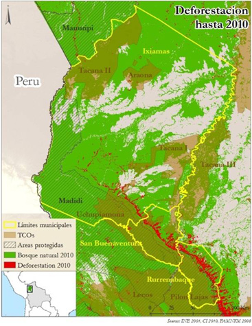
Given the importance of conserving the natural ecosystems in this area, we present an analysis of deforestation in the area known as “North of La Paz” , which is affected by the previously mentioned development strategy and located in the municipalities of San Buenaventura, Ixiamas, and Rurrenabaque. Out of the 4,269,533 ha in this area, 1,093,480 ha are indigenous territories (TCOs), and 926,073 are Protected Areas (APs). There is an overlap of 332,546 ha and therefore 40% of the lands are subject to sustainable management and protection. The rest of the land is under communal, private, or public land titles (typically managed without a sustainable management plan to begin with). In its origins, 79% of this area was covered by forest. By 2010, 124,674 hectares have been lost, equivalent to 4% of the initial forest cover.
Deforestation has occurred in the entire area, including APs and TCOs. In APs, 5,453 hectares have been deforested, equivalent to 1.1% of original forest cover. In the TCOs, 16,720 hectares have been deforested, equivalent to 2.7% of the original forest. In the overlap area, 6,851 hectares have been deforested (2.1% of initial forest cover). Out of total deforestation, 23% has occurred in areas under sustainable forest management, representing 2% of the initial forest in these areas. The remaining territories account for 77% of total deforestation (95,648 hectares), equivalent to 5.4% in these areas.
Considering that APs and TCOs have similar forest surfaces, we observe that APs have lower rates of deforestation. Even though TCOs deforest 3 times as much as APs, they still have low rates of deforestation considering that the population is much larger than in Protected Areas (APs). Together, these areas present only 23% of deforestation, meaning the remaining areas are the ones presenting major land-use changes.
Apparently, deforestation figures indicate that forest conservation is more effective in areas with sustainable forest management (APs and TCOs). However, by looking at annual deforestation rates within these managed areas in the 90’s, we observe that deforestation rates were around 1,599 ha/year, equivalent to 15% of total deforestation. Sadly, since 2005, deforestation in these areas accounts for around 25% to 30% of total deforestation. This makes us question the efficiency of conservation projects in these areas, as well as underlining the need to promote sustainable land use in the region.
For your reference:
Conservation International Bolivia (2012). Historical deforestation map 1976-2010, based on the Noel Kempff Mercado Natural History Museum map (2011).
LA PAZ DEPARTMENT PREFECTURE (2006). Integrated Program for Projects in the Northeastern Region of the La Paz Department. Study for technical-economical-financial feasibility: Ingenio Azucarero del Norte. La Paz – Bolivia.
Noel Kempff Mercado Natural History Museum (2011). Historical deforestation map 1976-2009.
This article was first published in the development communications magazine “Sociedad que Inspira” No. 17, August 2012.


